Monday, May 31, 2010

Beautifull Cascata delle Marmore in Italy


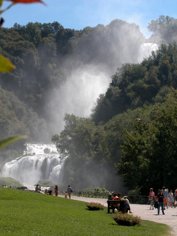
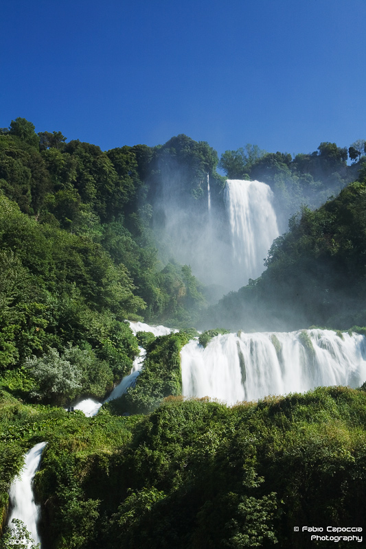
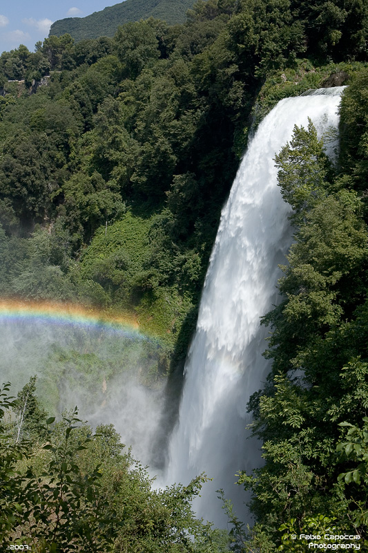
The Cascata delle Marmore (Marmore's Falls) is a man-made waterfall created by the ancient Romans. Its total height is 165 m (541 feet), making it one of the tallest in Europe and the tallest man-made waterfall in the world. Of its 3 sections, the top one is the tallest, at 83 m (272 feet).

It is located 7.7 km from Terni, a provincial capital of the Italian region of Umbria.

Its source is a portion of the waters of the river Velino (the rest of the river flows into a hydroelectric power plant), after flowing through Piediluco lake near the community of Marmore. It pours into the valley below formed by the river Nera. Its flow is turned on and off according to a published schedule, to satisfy the needs of tourists and the power company alike. Tourists try to be there the moment the gates are opened to see the powerful rush of water.
History :
The Velino river flows through the highlands that surround the city of Rieti. In ancient times, it fed a wetland that was thought to bring illness (probably malaria). To remove that threat to the city of Rieti, in 271 BC, the Roman consul Manlius Curius Dentatus ordered the construction of a canal (the Curiano Trench) to divert the stagnant waters into the natural cliff at Marmore. From there, the water fell into the Nera river below. However, that solution created a different problem: when the Velino river was in flood stage, its water flowed through the Nera toward the city of Terni, threatening its population. The issue was so contentious between the two cities that the Roman Senate was forced to address it in 54 BC. Cicero represented Terni, and Aulus Pompeius represented Rieti. The Senate did nothing about the problem, and things remained the same for centuries.

Lack of maintenance in the canal resulted in a decrease in the flow, until eventually the wetland began to reappear. In 1422, Pope Gregory XII ordered the construction of a new canal to restore the original flow (the Gregorian Trench or Rieti Trench).

In 1545, Pope Paul III ordered that a new canal be built (the Pauline Trench). The plan was to expand the Curian Trench and to build a regulating valve to control the flow. Upon its completion some 50 years later (in 1598), Pope Clement VIII inaugurated the new work, and named it after himself: the Clementine Trench.

In the following two centuries, the presence of the canal was problematic for the countryside in the valley below, as the Nera often flooded it. In 1787, Pope Pius VI ordered architect Andrea Vici to modify the leaps below the falls, giving the falls its present look and finally resolving the majority of the problems.

In 1896, the newly formed steel mills in Terni began using the water flow in the Curiano Trench to power their operation. In the following years, engineers began using the water flow to generate electricity.
source : http://en.wikipedia.org/

Saturday, May 29, 2010

Enjoy the Angel Fall in Venezuaela


Mini History :
Angel Falls (indigenous name: Parakupa-vena or Kerepakupai merú which means the fall from the highest point, in Pemon language; Spanish: Salto Ángel) is the world's highest waterfall, with a height of 979m (3,212ft) and a clear drop of 807m (2,647ft). It is located in the Canaima National Park (Spanish: Parque Nacional Canaima) , in the Gran Sabana region of Bolivar State, Venezuela.

The height of the falls is so great that before getting anywhere near the ground, the water is atomized by the strong winds and turned into mist. The mist can be felt a mile away. The base of the falls feeds into the Kerep River (alternately known as the Rio Gauya) which flows into the Churun River, a tributary of the Carrao River.

In the indigenous Pemon language Angel Falls is called Kerepakupai merú meaning "waterfall of the deepest place". The falls are sometimes referred to as Churun-meru, an error, since that name corresponds to another waterfall in the Canaima National Park. Churun in the Pemon language means "thunder".

article source : http://en.wikipedia.org/

Thursday, May 27, 2010

Sunday, May 23, 2010

The History of Bruges in Belgium

Bruges (Brugge) was founded in the 9th century by Vikings who settled here at the end of the little river 'de Reie'. The name Bruges is probably derived from the old-Scandinavian word 'Brygga', which means 'harbor, or mooring place'. Because of the proximity of the North Sea, the settlement very quickly became an important international harbor. A sea-arm, called the Zwin, connected Bruges with the North Sea. The young settlement acquired city rights as early as the 12th century. At that time a first protective wall was built around Bruges. Soon, however, the Zwin started to silt up. This would have caused major problems for the city, were it not that Bruges adapted itself to this situation by creating outports in Damme and in Sluis. Moreover, transport of goods over land became more and more usual. In the 14th century Bruges became the starting point of a commercial transport road to the Rhineland (over Brussels and Leuven, cities in Brabant which also started to flourish because of this trade).

The Bruges bear in the Porters Lodge.Already in the 13th century Bruges was an important international trading center. Traders from all over the then known world came to the city to sell their products to each other and to buy Flemish cloth, a internationally acclaimed textile product, produced in different Flemish cities (e.g. Gent). In the early 14th century Bruges was the scene of political unrest between the citizens and the count of Flanders. Because of this unrest the French king tried to annex the county of Flanders, but the population managed to kick out the French garisson on May the 18th 1302. Later the Flemish army beat the French army in the 'Battle of the Golden Spurs' on July the 11th in the Flemish city of Kortrijk.

In the 14th century Bruges turned also into an international financial and trading center. It became the wharehouse of the North-European Hanza cities. Several countries had their own representation in Bruges: the Italians, the Germans, the Scottish, the Spanish made the city into a true European center where different languages could be heard and where the most exotic products could be found.

The decline of Bruges' wealth started in the 15th century : the unstoppable silting up of the Zwin, the competition with the bigger harbor of Antwerp and the crisis in the cloth industry resulted in less commercial activity. The crisis, however, was not immediately noticable. Bruges continued to construct splendid late-gothic buildings and churches, and the Flemish painting school (with e.g. the brothers Van Eyck and Hans Memling ) started to flourish as never before.

By the end of the 16th century the former glory was only a memory and Bruges slipped into a wintersleep that took several centuries. New textile industries were introduced in the 19th century, but to no avail. In the middle of the 1800's Brugge was the poorest city in Belgium. The 20th century, however, brought new life. The city was discovered by the international tourism and the medieval heritage turned out to be a new source of wealth for the 'Venice of the North'. Economically and industrially another important evolution took place. The new harbor of Zeebrugge (Seabruges-at 10 miles outside of the city, at the Belgian coast) brought new developments and new industries to the region.
article source : http://www.trabel.com/brugge/bruges-history.htm

Friday, May 21, 2010

Beautiful City of Bath in England, Another Pictures


Bath is a city in the ceremonial county of Somerset in the south west of England. It is situated 97 miles (156 km) west of London and 13 miles (21 km) south-east of Bristol. The population of the city is about 80,000. It was granted city status by Royal Charter by Queen Elizabeth I in 1590,[2] and was made a county borough in 1889 which gave it administrative independence from its county, Somerset. The city became part of Avon when that county was created in 1974. Since 1996, when Avon was abolished,Bath has been the principal centre of the unitary authority of Bath and North East Somerset (B&NES).

The city was founded, among surrounding hills, in the valley of the River Avon around naturally occurring hot springs (the only ones in the United Kingdom, using the common definition of a spring with water above average human body temperature) where the Romans built baths and a temple, giving it the name Aquae Sulis. Edgar was crowned king of England atBath Abbey in 973. Much later, it became popular as a spa resort during the Georgian era, which led to a major expansion that left a heritage of exemplary Georgian architecture crafted fromBath Stone.

As City of Bath the city became a World Heritage Site in 1987. The city has a variety of theatres, museums, and other cultural and sporting venues, which have helped to make it a major centre for tourism, with over one million staying visitors and 3.8 million day visitors to the city each year. The city has two universities and several schools and colleges. There is a large service sector and growing information and communication technologies and creative industries, providing employment for the population ofBath and the surrounding area.
Source : Wikipedia

Tuesday, May 18, 2010

Enjoy The Beauty of Bath, England


The City of Bath England. A World Heritage City, visited by thousands of people from all over the world. On this site you will find a comprehensive listing with information on almost every aspect of visiting and living in Bath. Experience the richness and diversity that our City has to offer, from your-virtual window on the world.

Wednesday, May 12, 2010

Sunday, May 9, 2010