Wednesday, March 31, 2010

The Exotic Niagara Falls


The Niagara Falls are voluminous waterfalls on the Niagara River, straddling the international border between the Canadian province of Ontario and the U.S. state of New York. The falls are 17 miles (27 km) north-northwest of Buffalo, New York and 75 miles (120 km) south-southeast of Toronto, Ontario, between the twin cities of Niagara Falls, Ontario, and Niagara Falls,New York.

Niagara Falls is composed of two major sections separated by Goat Island: Horseshoe Falls, the majority of which lies on the Canadian side of the border, and American Falls on the American side. The smaller Bridal Veil Falls also is located on the American side, separated from the main falls by Luna Island. Niagara Falls were formed when glaciers receded at the end of the Wisconsin glaciation (the last ice age), and water from the newly-formed Great Lakes carved a path through the Niagara Escarpment en route to the Atlantic Ocean. While not exceptionally high,the Niagara Falls are very wide. More than six million cubic feet (168,000 m³) of water falls over the crest line every minute in high flow,[1] and almost 4 million cubic feet (110,000 m³) on average. It is the most powerful waterfall in North America.[2]

The Niagara Falls are renowned both for their beauty and as a valuable source of hydroelectric power. Managing the balance between recreational, commercial, and industrial uses has been a challenge for the stewards of the falls since the 1800s.
Article Source : http://en.wikipedia.org/wiki/Niagara_Falls

Tuesday, March 30, 2010

The Excellent Places to Hike Around Las Vegas

Travel to Las Vegas and you'll likely hear plenty about nearby attractions like the Grand Canyon, the Hoover Dam, and Lake Mead. There are even places right on the Strip where you can take part in guided tours of these places. These highly publicized attractions are well worth it and have many interesting sights and are great ways to escape the lights of Vegas. But in addition to these high traffic tourist spots, there are a couple of not so highly publicized areas that are well worth your time, and cost no more than a rental car and a camera.

Red Rock Canyon is located about 15 miles west of the Strip. It is just outside of the city - you can take Charleston Boulevard all the way there. Charleston crosses the strip just north of the Stratosphere. Hop on Charleston and go west. Once you pass RedRock Casino and Highway 215, you're almost there.

When you first get to Red Rock, there is a visitor's center where you can get out and check out some of the history of the canyon. You can learn about the Native American's who first lived in the area as well as the animals and plants that populate the canyon.

The canyon itself is made up of red sandstone which is very striking in color when the sun bounces off the canyon walls. There are numerous hiking trails that you can stop and hike. They range from easy to difficult. The canyon is also popular to rock climbers, who can often be seen scaling the cliffs and rocks of the area.

From the visitors center you can take the scenic loop, which is a 13 mile loop that winds its way through the canyon with numerous places to stop to either hike or take pictures. One of the stops along the loop is the Ice Box Canyon trail which is a two mile moderately difficult hike that includes some rock scrambling. This trail works it's way back into a canyon which is known for the cooler winds that blow through the rocks. While hiking be sure to look up the canyon walls as you can often see the climbers scrambling up their lines.

Along with the desert vegetation you're likely to see different animals in the conservation area. Bighorn sheep and deer accompany the wild burros that roam the land. The burros are rather tame and will often come up to car windows looking for food - though it is recommended not to feed them as this increases their independence on the tourists of the area. A picture of a burro sticking his head in your car window is often a great picture to share with friends back home.

The great thing about Red Rock is that you can see the sights without ever leaving the air conditioning of your car - or if you're feeling a little adventurous you can venture out on one of the trails and make your way a little off the beaten path. Even though you are just outside the sprawling city of Las Vegas, a trip to RedRock is a great escape from the hustle and bustle of the city - a great way to take a vacation inside your vacation.

By: Patrick Treadway

Monday, March 29, 2010

Arkansas' Natural Treasure: Maumelle Park in Amerika


Arkansas is not called, "The Natural State", for any old reason. The state of Arkansas is home to a fabulous wealth of mountainous landscapes, valleys, plains and woodlands. Positioned not far from the state capital of Little Rock is the Pinnacle Mountain Valley, a 2000 acre site situated around the foothills of the Ouachita Mountains. Within the beautiful Pinnacle Mountain Valley is the Maumelle State Park, one of Arkansas' natural treasures and also one of the top locations for visitors to the Little Rock area, especially for all nature-lovers.

At Maumelle Park, visitors will find a diversity of wildlife in a variety of habitats. The area may be of particular interest to bird watchers, as it attracts an exciting assortment of birds and wildlife. Hikers are also well catered for, with various hiking trails traversing the region, so visitors who enjoy nature walks will find Maumelle Park and the surroundingPinnacle Mountain Valley a delight; these trails include the Arkansas Trail through the Arkansas Arboretum (a 71-acre site dedicated to representing Arkansas ' six main natural divisions); the Kingfisher Trail next to the Little Maumelle River; and the 223-mile Ouachita National Recreation Trail.

With so many hiking trails to enjoy, visits to Maumelle Park can often exceed the remits of a day trip. But with over 129 campsites to choose from, all of which are equipped with water and electricity, visitors to Maumelle Park will find camping a comfortable experience. Maumelle's Parks campsites are also open to visitors to the neighbouringPinnacle Mountain State Park, which has no camping areas of its own. Its optimal site is situated just next to the Arkansas River which means that campers can enjoy beautiful vistas, as well as tables and grills nearby, bathhouses with hot water, a playground and a boat ramp for anyone wanting to sail or paddle through the park rather than hike.

However much you enjoy the beauty of Maumelle Park, camping may not always seem to be the most enjoyable mode of accommodation for a vacation, especially when with family members. Thankfully however, Maumelle Park is only a convenient fifteen minute drive away from the city of Little Rock where you can choose from a number of comfortable hotels. Maumelle Park's proximity to Little Rock means that visitors, if they choose to stay in the city, can enjoy the comforts of urban accommodation whilst revelling in the delights of the park's natural scenery and clean mountain air. Many of the hotels in Little Rock often offer package deals for larger parties, so that groups or families travelling together can often find some great deals to enjoy during their holiday to Maumelle Park.

By: Michael Hanna
Michael is a keen writer living in Edinburgh. Michael's Website: Belfast Airport Taxis.

Saturday, March 27, 2010

Nicaragua Travel Destination


Wedge-shaped Nicaragua may be the largest country in Central America, but it is also one of the least visited. Even after more than a decade of peace, Nicaragua is synonymous in the minds of many with civil war; this reputation, when coupled with the dilapidated infrastructure of a country that has fought its way not only through a bloody conflict but also an American economic blockade, scares many off. Still, many travelers who spend any time there find - much to their surprise - thatNicaragua is their favorite country in the isthmus. Perhaps because it doesn't yet fully cater for the tourist experience, Nicaragua is an incorrigibly vibrant and individualistic country, with plenty to offer travelers prepared to brave Nicaragua's superficial obstacles of economic chaos, cracked pavements and crammed public transport.

Thursday, March 25, 2010

The Best Travel Destinations of history Rhodes in Greece


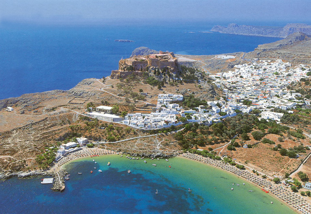
ACROPOLIS OF LINDOS Lindos is its rock
This rock, which rises to 116 m. forms the finishing touch to the landscape of Lindos, standing dry and imposing in its bareness and surrounded on all sides by the sea, so that Lindos ,may rejoice in the ocean, in the words of a hellenistic epigram. Lindos does not seem to have been particularly important in the earlier periods, though sporadic finds of the Neolithic period and the Bronze Age have been discovered on theacropolis. According to legend, the foundation of the sanctuary of Athena Lindia goes back to the Mycenaean period, and Mycenaean finds have been yielded by cemeteries in the broader area of Lindos. The Archaic period (7th-6th c BC) was a golden age for Lindos, which played a leading role in the Greek colonisation movement, its most important foundation being Gela in Sicily. The 6th c BC was dominated by the figure of a moderate tyrant, Kleoboulos who ruled Lindos for many years, and was Included amongst the �seven sages� of the ancient world.
During his rule, the Archaic temple of Athena was built on the site of an earlier structure, and the acropolis received its first monumental form. The Persian advance and later the merger of the three old cities into the new city of Rodos (408 BC) led to a diminution in the importance of Lindos as a political and economic power.
It nevertheless continue to be an important centre, focused on the famous sanctuary of Athena, which received its final monumental form in the Hellenistic period and became the leading sanctuary on the island. The acropolis was used as a fortress in antiquity, as well as In Byzantine times, in the period of the Knights of St. John, and in that of Ottoman rule.
Today, the ascent to the acropolis is still by the same steep road as in antiquity. After the first outer entrance to the medieval fortress, and before beginning to climb the large stairway that leads up to the Administrative Building ofthe Knights, we encounter two important monuments on our left a semicircular Hellenistic exedra, and, next to it, a depiction of the prow of an ancient ship carved in relief in therock , which formed the base of a statue of Agesandros son of Milkion, the work of the sculptor Pythokritos in the early 2nd c. BC The fortification of Lindos bythe Knights goes back to the 14th-15th c AD.
Passing through the ground - floor of the Knights Administrative Build Building, we emerge into a large square, which occupies the lowest level of the acropolis and was full of votive offerings in ancient times. A row of vaulted structures, built in the l st c. BC, stood on either side of a stairway leading up to the level of the large Hellenistic stoa, built ca. 200 BC. The large stairway behind the stoa leads up to the highest level where are to be found the Propylaia and thetemple of Athena, which formed the main sacred precinct.The temple was completely isolated from the outside world by a wall with five entrances. In front of and behind it were stoas with rooms. The inner stoa flanked a courtyard in front of thetemple, in which there was probably an altar. The temple , which measures about 22x8 m is a Doric, amphiprostyle tetrastyle structure. It was constructed in the 4th c. BC or in the early Hellenistic period on the site of Kleoboulos�temple, which had burned down in 392 BC. It stands at the highest point of the rock and was the culmination of the stepped vista offered by the stoa and the Propylaia to anyone ascending to the acropolis.

From the highest point of the acropolis can be seen the lower city, in which the most important monuments still visible are the theatre, the Tetrastoon and the Archokrateion at Kambana, a monumental tomb of an important Lindian family. The Byzantine church of the Panayia is also in the lower city. it was built It In the 15th c. and decorated with wall-paint paintings in the 17th and 18th c. The traditional settlement of Lindos is in a very good state of preservation. A large number of archontika (mansions) survive, the most Important of them from the 17th c., indicating that Lindos was a flourishing naval power in the early period of Turkish rule, as indeed throughout its entire history.
The Lindos Castle is found on the top of a 116m rock and serves as an entrance point to the Acropolis and the temple of Athena and once was used as the administrative building of the Knights. Today, the ascent to the acropolis Is still by the same steep road as in antiquity. After the first outer entrance to the medieval fortress, and before beginning to climb the large stairway that leads up to the Administrative Building ofthe Knights, we encounter two important monuments on our left a semicircular Hellenistic exedra, and, next to it, a depiction of the prow of an ancient ship carved in relief in therock, which formed the base of a statue of Agesandros son of Milkion, the work of the sculptor Pythokritos in the early 2nd c. BC

The fortification of Lindos by the Knights goes back to the 14th-15th c AD. Passing through the ground - floor of the Knights Administrative Build Building, we emerge into a large square, which occupies the lowest level of the acropolis and was full of votive offerings in ancient times.
http://www.faliraki-info.com/lindos/history.htm
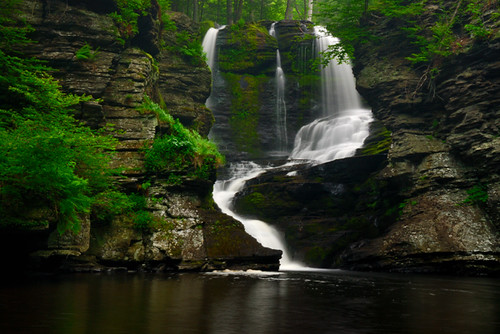
Wednesday, March 24, 2010

Exotic Fulmer Falls at Pennsylvania


A waterfall is usually a geological formation resulting from water, often in the form of a stream, flowing over an erosion-resistant rock formation that forms a nickpoint, or sudden break in elevation.Some waterfalls form in mountain environments in which the erosive water force is high and stream courses may be subject to sudden and catastrophic change. In such cases, the waterfall may not be the end product of many years of water action over a region, but rather the result of relatively sudden geological processes such as landslides, faults or volcanic action. In cold places, snow will build up in winter and melt and turn into a waterfall in summer

Tuesday, March 23, 2010

Milford Sound at New Zealand : Best Travel Destinations


Milford Sound (Piopiotahi in Māori) is a fjord in the south west of New Zealand's South Island, within Fiordland National Park and the Te Wahipounamu World Heritage site. It has been judged the world's top travel destination in an international survey, and is acclaimed as New Zealand's most famous tourist destination. Rudyard Kipling had previously called it the eighth Wonder of the World.
Etymology
Milford Sound is named after Milford Haven in Wales, while the Cleddau River which flows into the sound is also named for its Welsh namesake. The Māori named the sound Piopiotahi after the thrush-like piopio bird, now extinct. Piopiotahi means "a single piopio", harking back to the legend of Māui trying to win immortality for mankind - when Maui died in the attempt, a piopio was said to have flown here in mourning.
Geography

Milford Sound runs 15 kilometres inland from the Tasman Sea and is surrounded by sheer rock faces that rise 1,200 metres or more on either side. Among the peaks are The Elephant at 1,517 m (4,977 ft), said to resemble an elephant's head,[5] and Lion Mountain, 1,302 m (4,271 ft), in the shape of a crouching lion.[6] Lush rain forests cling precariously to these cliffs, while seals, penguins, and dolphins frequent the waters.
Climate

With a mean annual rainfall of 6,813 mm on 182 days a year,[7] a high level even for the West Coast, Milford Sound is known as the wettest inhabited place in New Zealand and one of the wettest in the world. Rainfall can reach 250 mm during a span of 24 hours.[8] The rainfall creates dozens of temporary waterfalls (as well as a number of major, more permanent ones) cascading down the cliff faces, some reaching a thousand metres in length. Smaller falls from such heights may never reach the bottom of the sound, drifting away in the wind.

Accumulated rainwater can at times cause portions of the rain forest to lose their grip on the sheer cliff faces, resulting in tree avalanches into the sound. The regrowth of the rain forest after these avalanches can be seen in several locations along the sound.
http://en.wikipedia.org/wiki/

Monday, March 22, 2010

The Italian coastline Shot


Arriving into the little village of Barissa just off the Italian coastline, I knew this was the perfect place for me to unwind and relax for a few days after spending to much time in big cities. This place is a very small village in the hills with only 1 shop and 1 restaurant and the mandatory church which rings the bell right on each hour including at ridiculous times of the morning. The few days I spent here were some of my favourite days of the trip so far and was a welcome escape from the hustle and bustle of Rome. While the area is still very heavily touristed this time of year was quite a good time to go as the weather was still perfect yet the summer crowds were long gone. The first day was spent hiking between each village, walking along the cliff faces that lined the bluest ocean ive seen. Each village was the typicalItalian style village and it was a good opportunity to see people going about their everyday lives. The hike from one end to the other is only about 14km and is not all that difficult but makes you earn that beer at the end. For the other days of my stay I would get the train to one of the villages and just hang out for the day eating pizza and gelati and just watching the world go by. Saw an amazing sunset on the final day which was the perfect way to end my stay in this beautiful part of the world. Before I finish this entry I have to say that this is a must stop for anyone going to Italy but I think in summer the crowds would be to much to handle and would really take away from the experience. Speaking of crowds im off to Venice for a while before its time to take on the eastern European countrieshttp://www.travelpod.com/

Sunday, March 21, 2010

Brief History of Sukhothai Park


The Sukhothai Historical Park covers the ruins of Sukhothai, capital of the Sukhothai kingdom in the 13th and 14th centuries, in what is now the north of Thailand. It is located near the modern city of Sukhothai, capital of the province with the same name.

The city walls form a rectangle about 2 km east-west by 1.6 km north-south. There is a gate in the centre of each wall. Inside are the remains of the royal palace and twenty-six temples, the largest being Wat Mahathat. The park is maintained by the Fine Arts Department of Thailand with help from UNESCO, which has declared it a World Heritage Site. The park sees thousands of visitors each year, who marvel at the ancient Buddha figures, palace buildings and ruined temples. The park is easily toured by bicycle or even on foot.

Wednesday, March 17, 2010

The Exotic Phi Phi island at Thailand


Phi Phi island consists of two islands, Phi Phi Don, the larger one of the two with an abundance of fine beaches and accommodation to suit all needs. The more geographically dramatic, Phi Phi Ley, with its cliffs, natural caves and water-filled canyon offers the tourists exciting and outdoor pursuits. Both islands are in Krabi province and are part of Nopparat Thara Beach/Phi Phi National Marine Park, Just a short 42 kilometers from from Phuket, will transport you to the tropical paradise and famous islands of Phi Phi Island. With a Kodak moment with every view, it's the ultimate tropical getaway in Thailand.

Sunday, March 14, 2010

Beautiful Thailand : Kamphaeng Phet at Thailand


Kamphaeng Phet is an important province. During the Sukhothai era, it was a town whose status was recognized as that of the crown ruling town, it is presumed to have been established in 1347 during the Reign of King Ler Thai, the 4th King of the Sukhothai dynasty and it was called "Cha Kang Rao and "Nakhon Chum" Kamphaeng Phet occupies an area of 8,607.5 square kilometers and is located 358 kms. from Bangkok. This province is in the lower Northern Region, having its territory bordering on: Tak and Sukhothai.
The old town of Kamphaeng Phet, classified by UNESCO with the World Inheritance of Humanity in 1991, skirting the ruins of Sukhothai,is in the Historical Park of Kamphaeng Phet.

With its historical museums and its old ruins, this province is an interesting stage at the time of a voyage to the north of Thailand and beyond.

Monday, March 8, 2010

Orchard Road at The Night


Orchard Road at The Night Picture

Exiting Marina Bay at the Night


Exiting Marina Bay at the Night